Last update: March 11, 2025
Dear Curious Souls, if you’re planning to visit Iceland soon, knowing the evacuation routes in Reykjanes in case of volcanic risks is essential. The Reykjanes Peninsula in Iceland is currently experiencing increased volcanic activity, but don’t panic! 🌋 As responsible travelers, getting informed about available evacuation routes will allow you to enjoy Iceland’s natural wonders with peace of mind.
I recently explored this region and want to share with you all the necessary information to travel safely. This comprehensive guide will help you understand the current situation and know the real-time evacuation routes.
- Current Volcanic Situation in Reykjanes
- Evacuation Routes in Iceland: Main Hazards in Case of Eruption 🚨
- Evacuation Routes in Reykjanes, Iceland: Detailed Guide by Zone
- Preparation for Volcanic Alerts: Evacuation Routes in Iceland 📱
- Iceland's Expertise in Facing Volcanic Eruptions
- Frequently Asked Questions about Evacuation Routes
- Conclusion: Responsible Travel in a Geological Paradise
Current Volcanic Situation in Reykjanes
Currently, no eruption is ongoing in the Reykjanes Peninsula. However, Icelandic authorities report an increased possibility of volcanic activity in the coming weeks. This region, known for its exceptional geothermal activity that you can admire at the Blue Lagoon, is currently experiencing land uplift and magma accumulation beneath Svartsengi.
Seismic activity in the Sundhnúksgígaröðin region remains relatively stable, with approximately five earthquakes per day in February. These tremors are generally of low intensity and are part of everyday life in Iceland. If you visit the Katla Geopark, you can learn more about this incredible, constantly evolving geology.
Areas to Watch Particularly
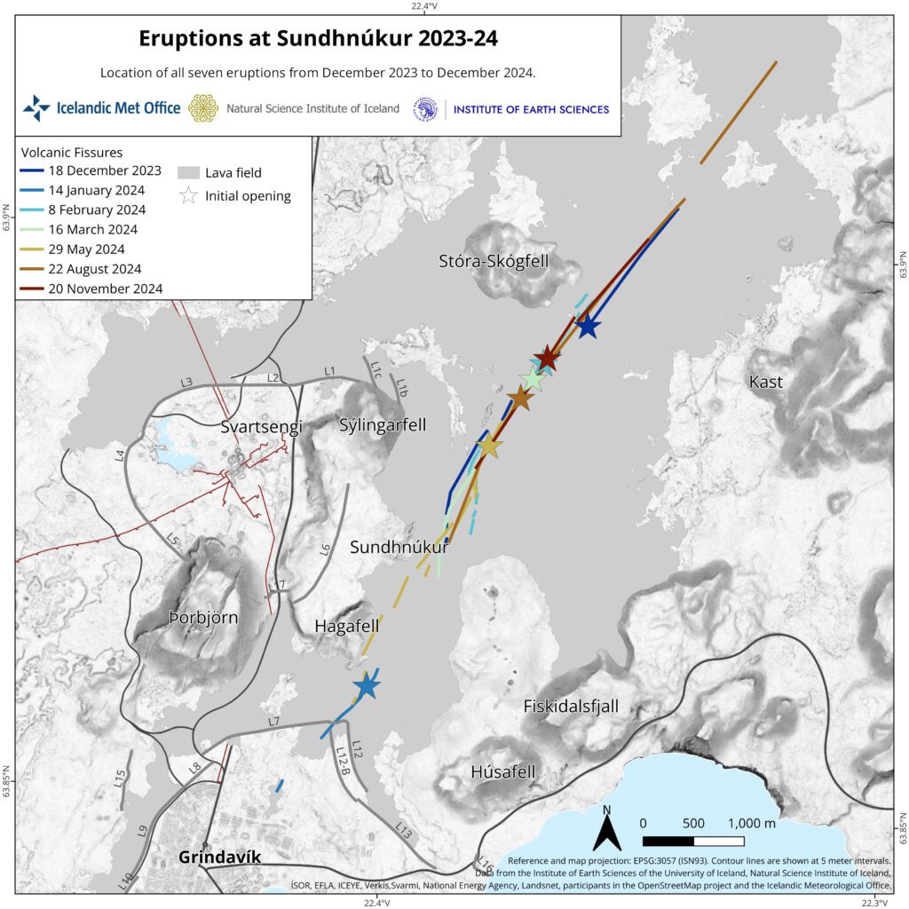
According to experts, the areas most likely to experience an eruption are located between Sundhnúkur and Stóra-Skógfell, as was the case for six of the last seven eruptions since late 2023. The eruptive fissure could then propagate towards the northeast and/or southwest over several kilometers.
There is also a possibility of an eruption near or south of Hagafell, as was the case in January 2024. This scenario would offer a longer warning time of about 1 to 5 hours, unlike eruptions between Sundhnúkur and Stóra-Skögfell which could occur with very little or no warning.
Evacuation Routes in Iceland: Main Hazards in Case of Eruption 🚨
If you’re visiting the Reykjanes Peninsula, it’s essential to know the main volcanic risks and corresponding evacuation routes. This information is not meant to frighten you but to allow you to travel with confidence and responsibility.
Potential Risks
In case of an eruption, several phenomena could occur:
- Opening of eruptive fissures: This process can be very rapid, reaching several kilometers in less than an hour. During previous events, eruptive fissures continued to propagate between 40 minutes and 7 hours and reached lengths between 1.7 and 6 km.
- Lava flows: Lava could reach Grindavíkurvegur or Svartsengi in less than 1.5 hours. If you’ve planned to observe whales in Iceland in winter, make sure to regularly check updates regarding road accessibility.
- Gas pollution: A strong initial phase in an unfavorable wind direction could pose a danger due to gas pollution within a radius of up to 1 km.
- Explosive activity: This could occur if lava flows over ponds or comes into contact with groundwater.
In case of an eruption near or south of Hagafell, additional hazards should be considered:
- Lava flows toward roads: Lava could reach Nesvegur and Suðurstrandavegur within 1.5 hours and potentially block all evacuation routes from Grindavík in about 6 hours.
- Lava reaching the sea: Lava could reach the sea east of Grindavík in 1.5 to 3 hours, creating extremely dangerous conditions within a 200-meter radius of the point where lava enters the sea.
Reykjanes Evacuation Routes Map: Volcanic Risk Zones
The current hazard map, valid until March 18, 2025 (unless there are new developments), divides the region into several zones with different danger levels. Each zone has clearly marked evacuation routes that you should identify as soon as you arrive.
The colors on the map represent the overall hazard level in each zone:
- 🔴 Red zone: Extreme danger, access forbidden
- 🟠 Orange zone: High danger, immediate evacuation in case of alert
- 🟡 Yellow zone: Moderate danger, stay vigilant and ready to evacuate
- 🟢 Green zone: Relative safety zone
Evacuation Routes in Reykjanes, Iceland: Detailed Guide by Zone
Zone 4: The Town of Grindavík
The town of Grindavík is currently open to visitors, but authorities advise against going there due to its proximity to potential eruption sites. The town has been heavily affected by earthquakes and recent volcanic activity.
Grindavík evacuation routes:
- North route: Follow the main road (Grindavíkurvegur/Route 43) towards Reykjavík
- East route: Use Suðurstrandavegur (Route 427) towards Þorlákshöfn
- Assembly points: Gathering areas are clearly identified in the town by green signs
⚠️ In case of an eruption, an alarm will sound in the town to signal evacuation. Note upon your arrival the closest and quickest way out of town. Evacuation routes are clearly marked.
If you want to discover the Solheimasandur plane wreck, know that this attraction is located east of the peninsula and is generally less affected by current volcanic activity.
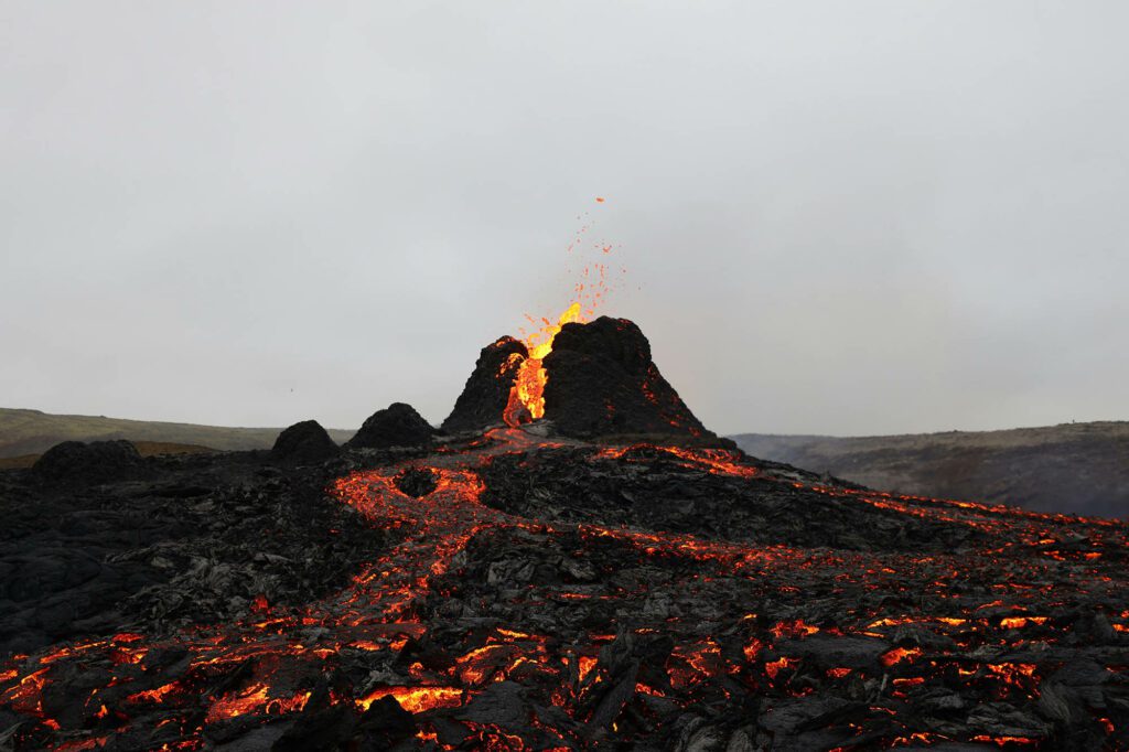
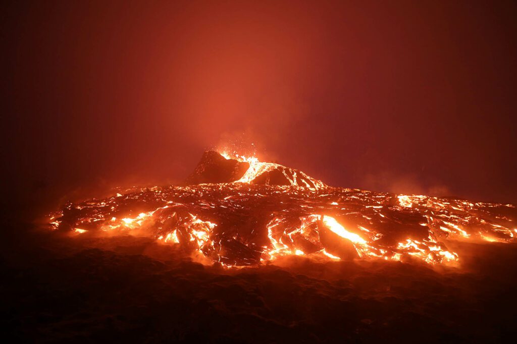
Zone 3: Sundhnúkagígar Eruption Site
This area has an increased possibility of volcanic eruption. Scientists state that an eruption could occur without any prior warning. Therefore, hiking to the eruption site is strongly discouraged.
Sundhnúkagígar evacuation routes:
- Evacuation to the west: Follow the marked trails towards Route 43
- Evacuation to the north: Use the marked paths towards Route 41
- Exit points: Clearly visible evacuation signs indicate the fastest exits
⚠️ In this area, the ground is unstable with cracks and holes that may not be visible. Never venture off the marked trails.
If you’re interested in volcanic phenomena while staying safe, I instead recommend visiting Geysir, which offers an impressive geothermal spectacle without the immediate dangers of an active eruption zone.
Mt. Fagradalsfjall (2021-2023 Eruption Site)
Mount Fagradalsfjall, site of the 2021-2023 eruptions, remains accessible but could be temporarily closed in case of an eruption at Sundhnúkagígar. If you visit this area, stay alert for any signs of eruption and be ready to evacuate the area immediately if necessary.
Recommended routes and evacuation points:
- P1: Recommended parking point, with a well-marked hiking trail to the viewpoint of the eruption site (red trail on the map)
- P2: Another parking option for a shorter hike to one of the lava flows at Nátthagi
- Evacuation routes: Yellow signs indicate the fastest evacuation paths
⚠️ Disable airplane mode on your phones during your visit, as information regarding an eruption may be transmitted via SMS. This area features mountainous terrain, dress according to the weather.
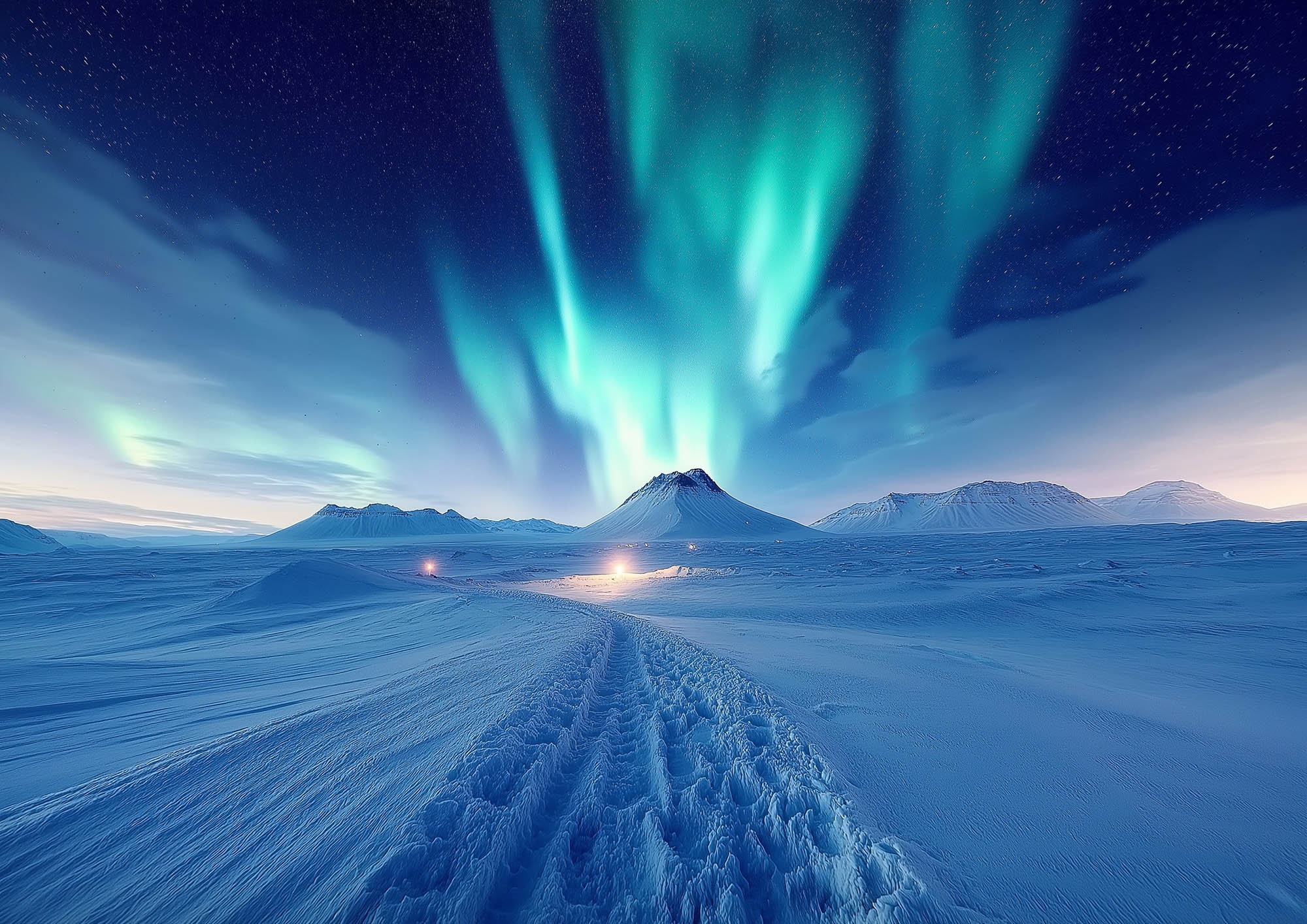
Before setting out on a hike, check our guide on Northern Lights in Iceland — if conditions are favorable, you might combine observing volcanic phenomena with Northern Lights for a truly unforgettable experience!
Preparation for Volcanic Alerts: Evacuation Routes in Iceland 📱
Iceland has a sophisticated alert system to warn residents and travelers in case of an imminent eruption. Here’s how to stay informed and prepared:
Alert System and Evacuation
In case of an eruption, several alert mechanisms will be activated:
- Alarm sirens in inhabited areas like Grindavík
- Emergency text messages sent to mobile phones in the area (make sure your phone is on and not in airplane mode)
- Radio and television announcements in Icelandic and English
- Notifications via official apps like the Icelandic Meteorological Office app
Essential Apps and Resources
To stay informed in real-time, download these apps and check these websites:
- Icelandic Meteorological Office: Information on seismic activity and the development of events
- Icelandic Road Administration: Information on road conditions and closures in the Reykjanes region
- Safetravel: Updates on safety for travelers in Iceland
- Icelandic National Broadcasting Service: News coverage
- Visit Reykjanes: Updates from the region
Keep these sites in your favorites and check them daily during your stay. If you plan to visit the Blue Lagoon, check its opening status just before your visit, as it is located in an area that could be affected by volcanic activity.
Recommended Equipment 🎒
If you plan to visit the Reykjanes Peninsula, bring with you:
- A charged mobile phone with the apps mentioned above
- A power bank for your phone
- A paper map of the region with marked evacuation routes
- Water and snacks
- Clothing adapted to changing weather conditions (as for any hike in Iceland)
- A face mask or scarf (protection against volcanic gases if necessary)
- A headlamp or torch (evacuations can happen at any time)
Iceland’s Expertise in Facing Volcanic Eruptions

I was impressed by the level of preparation of Icelanders facing volcanic eruptions. Their alert systems, evacuation plans, and ability to inform tourists gave me a sense of security despite the unpredictable nature of volcanoes.
Iceland is no stranger to volcanic activity and experiences an average volcanic event every five years. Icelandic authorities and the public are highly prepared for such events, and Iceland has one of the world’s most effective volcanic preparedness measures.
Icelandic geoscientists possess vast experience in dealing with volcanic activities. They constantly monitor the country’s volcanoes and provide real-time updates to the authorities, allowing them to make informed decisions and take necessary precautions.
This expertise allows you to travel with peace of mind, even in a volcanically active region like Reykjanes. If you follow the advice and stay informed, you will be able to fully enjoy your stay while staying safe.
If you want to learn more about Icelandic geology, I recommend visiting Thingvellir National Park, where you can observe the separation of the North American and Eurasian tectonic plates.
internet
Ne laissez pas Internet à la maison en voyage
Airalo est la solution idéale pour rester connecté en permanence lors de vos voyages. Leur eSIM permet d’obtenir facilement et rapidement des données mobiles à l’étranger.
Frequently Asked Questions about Evacuation Routes
Is it safe to visit the Reykjanes Peninsula currently?
Yes, it is generally safe to visit the Reykjanes Peninsula, but with certain precautions. Danger zones are clearly identified and evacuation routes well marked. Avoid areas marked as dangerous and stay informed of the latest updates.
How will I know if there is an eruption alert?
In case of an imminent eruption, several alert systems will be activated:
- Alarm sirens will sound in inhabited areas
- Text messages will be sent to mobile phones in the area
- Announcements will be made on radio and television
- Official apps will send notifications
Are flights to Iceland affected by this volcanic activity?
Currently, flights are not affected. Recent eruptions in the Reykjanes Peninsula have mainly produced lava flows and little ash, which limits their impact on air traffic. However, check with your airline before departure and regularly consult the Reykjavik Airport (KEF) website.
Is the Blue Lagoon accessible?
The Blue Lagoon generally remains accessible, but its location in an area potentially affected by volcanic activity means its status can change rapidly. Always check the latest information before your visit. If you plan to have lunch at the Lava Restaurant at the Blue Lagoon, also make sure to verify its opening status.
What should I do if I am in the area during an eruption?
In case of an eruption:
- Stay calm and follow the instructions of the authorities
- Head immediately to the nearest evacuation route
- Do not try to approach the eruption or photograph it
- Move to the designated assembly points
- Keep your phone on to receive updates
- If you are in a car, follow the marked evacuation routes without creating traffic jams
Conclusion: Responsible Travel in a Geological Paradise
The Reykjanes Peninsula remains one of the most fascinating destinations in Iceland, where the power of nature manifests in spectacular ways. As Curious Souls, we encourage you to explore this region while respecting safety instructions and knowing the evacuation routes.
Volcanic activity is an integral part of Icelandic identity and can even enrich your travel experience. The opportunity to observe active geological phenomena is a privilege that comes with responsibilities.
Stay informed, be prepared, and you will be able to fully enjoy all the wonders that this land of fire and ice has to offer. Your safety is paramount, but it should not prevent you from having authentic and transformative experiences.
Don’t forget that if you want to combine observing volcanic phenomena with Northern Lights, winter is the ideal period to maximize your chances of seeing these two extraordinary natural spectacles.
Safe travels, and stay curious! 🌋✨
Note: Information on evacuation routes is based on official data from the Department of Civil Protection and Emergency Management of Iceland. Last update: March 11, 2025. Please check the most recent information before your trip.
Article mis à jours le 12 March 2025 par Pierre Bouyer


No Comments